How big is Moscow’s Red Square in comparison to Tiananmen Square?
Why are there less public squares in Japan than in Italy?
What lessons might be found in the plan of Savannah, Georgia’s historic district?
What is the connection between New Haven, Connecticut and Cleveland, Ohio?
To Scale is a collection of plans of urban spaces drawn at the same scale to help answer these and other questions by providing a single and accurate resource of urban plans for architects, urban designers and teachers and students in these fields.
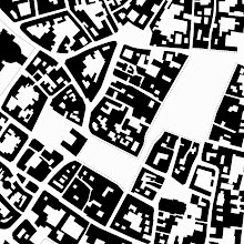
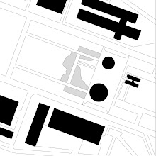
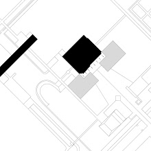
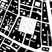
The book contains one-hundred figure-ground plans from seventy-eight cities from around the world. Accompanying each plan are photographs, diagrams and texts that illustrate essential aspects of the plan or urban space for the designer. Rather than purely historical description, the text attempt to explore those lessons that might be found in the urban condition. Also included is a bibliography on urban design and additional map sources.
The particular use of the book is three-fold: To See, To Compare and To Reconceptualize
To See
To Scale provides designers with an unprecedented collection of accurately and consistently drawn plans of urban spaces all drawn at the same scale. Through it they can see how these figure/ground plans can represent concisely a city’s building and spatial pattern. While designers may find plans in varied publications or even refer to tourist or road maps, these plans are often drawn inconsistently, at dissimilar scales or even incorrectly. Compiling accurate and authoritative plans-- those drawn by an authority such as a government agency or scientific body whose intentions were to convey legal rather than tourist or historical information--is usually a logistical challenge. To Scale will be the first published source of one-hundred figure/ground plans of urban spaces drawn at the same scale in a consistent manner.
To Compare
To Scale allows designers to compare the interrelationship of the scale, size and patterns of urban spaces and thus begin to understand their differences and similarities. Precedent figure/grounds of important spaces can help designers, regardless of their experience, make successful public spaces for the 21st century. But this comparison is not as easy as it might sound. For example, without To Scale, comparing plans of Savannah, Georgia and New Haven, Connecticut might require several days of research. If and when the plans are found, the two plans are more than likely to be scaled and drawn differently and, surprisingly, are often inaccurate. Authoritative and accurate plans in one source will allow extensive and rapid comparative analyses.
To Reconceptualize
To Scale helps designers reconceptualize existing urban spaces as they conceive new urban spaces. Students and even more experienced designers may have difficulty conceptualizing an urban space or their own design project’s site. To Scale gives these designers a point of reference as they insert spaces that are familiar into unfamiliar spaces or sites. This insertion immediately scales the site and helps designers see it anew. Through this analysis they can better understand differences and similarities of spaces and see the scale of spaces in relation to those spaces with which they may be familiar. This rethinking and revisiting is timely as “smart growth” initiatives ask designers for denser, sustainable livable communities and sites and projects become increasingly aware of the environmental impact of buildings on the landscape.
skip to main |
skip to sidebar

Eric J. Jenkins
One Hundred Urban Plans
To Order On Line
Routledge 2008
Now available in the United States and Europe
Arras
Barcelona Eixample
Bath
Brasilia
Chandigar
Paris Place des Vosges
Eric J. Jenkins
To Scale, Too!
See Joshua Simoneau’s 3-D modeling of To Scale
http://www.youtube.com/watch?v=OYASjeePZto&feature=related
Links
Here are a few links that may be helpful for those interested in urban design:
Project for Public Spaces
Good, if populist, resource on public spaces. The authors take a more "I know art when I see it" approach but otherwise is a fairly common sense attitude toward public spaces throughout the world. http://www.pps.org/
Urban Design
UrbanDesign.org is based in Alexandria, Virginia. The site has a wide range of topics including information on transportation, conferences, books and examples of good, if at times nostalgic, urban design projects (Other than Europe and Canada, is there a U.S.-based "new urbanist" who has produced work that looks like it's been designed in and for the 21st century? The idea that new towns should be clothed in pre-industrial garb but wired for the 21st century is somewhat disturbing. ) http://www.urbandesign.org/
Stadtkreation
This site, created by a German urban designer, is a good sources of urban design projects, texts and links. http://www.stadtkreation.de
RUDI-Resource for Urban Design Information
Resource for Urban Design Information (RUDI) is a UK based web resource dedicated to urban design and place making. http://www2.rudi.net
Catholic University’s Master of Architecture Urban Design Concentration
http://architecture.cua.edu/academicprograms/urbandesign.cfm
Models of Ancient Rome
http://www.maquettes-historiques.net/P5.html
Nolli Plan
http://www.lib.berkeley.edu/EART/maps/nolli.html